🧵⛰️🍃En la segunda y última parte de los hilos de meteorología mesoescalar vamos a hablar sobre fenómenos que tienen que ver con la orografía como las ondas de montañas y circulaciones de viento como las brisas, además de las lluvias de los frentes y la inestabilidad asociada.


En el anterior hilo definí lo que era la mesoescala y hablé de las tormentas, su formación y los fenómenos que creaba
Rescato este cuadro del hilo anterior para que veáis la cantidad de fenómenos que me faltan por contar y tienen que ver con la orografía y por fronteras de masas de aire. Vamos a empezar hablando de los fenómenos que crean la presencia de montañas.

La orografía puede provocar puede influir tanto a escala planetaria y local, debido a que fuerza al flujo de viento a cambiar su dirección de movimiento, creando toda clase de ondas atmosféricas que pueden crear desde circulaciones estratosféricas a pequeñas nubes.
Para entender mejor cómo influye en el viento, imaginemos que tenemos un perfil de montañas sinusoidal (como las que dibujábamos en el cole). Cuando el viento llegue a la primera montaña va tener que ascender y descender siguiendo el perfil montañoso.

Lo que está provocando esa cadena montañosa es que el perfil de viento se ondule, es decir, están creando ondas atmosféricas. Las montañas están produciendo cambios en las fuerzas de empuje porque está obligando a ascender y descender al aire
Os recomiendo mirar el hilo de ondas del que viene el tuit anterior. Como vimos en ese hilo, a partir de las ecuaciones de onda podemos estudiar qué forma tomará la onda conforme nos alejamos de la cadena motañosa.
Esas ecuaciones nos dicen que, dependiendo de si lA anchura de las montañas que forman esa cadena es grande o no, el perfil de vientos se ondulará menos con la altura. Para montañas anchas, el perfil de vientos no se atenúa con la altura (a), pero para estrechas sí (b).

Tuit técnico: aquí os resumo las condiciones que se tienen que dar, que depende de la velocidad del viento, el número de onda y la frecuencia de flotabilidad (el parámetro que indicaba si la burbuja ascendía o no, imagen derecha). Se asume que N es constante


Sin embargo, en la realidad está claro que las montañas no son como en el dibujo anterior, por eso en meteorología mesoescalar se estudia el efecto que tiene una sola montaña en el flujo de viento. En este caso no podemos un único tipo de onda, si no la suma de muchos tipos.
Cada onda tendrá una frecuencia o longitud diferente. Esto se expresa en matemáticas como series de Fourier. Si nos quedáramos con un solo término, obtendríamos soluciones como la que dije hace dos tuits
Los anteriores casos eran si eran mayor o menor que N, pero sí son casi iguales ahora la energía se transferirá sobre todo en la vertical y cerca de la montaña. El perfil de viento será muy diferente, pudiendo formarse incluso nubes donde se supera el nivel de condensación.

Vamos a permitirnos otro caso, ahora varían con la altura el viento promedio <u> y la estabilidad en la atmósfera puede variar, por tanto varía N y cambian las fuerzas de empuje. Por ejemplo imaginemos, que <u> aumenta fuertemente con la altura y N decrece fuertemente.
En este caso pueden alternarse los casos anteriores, cerca de la superficie habrá ondas que se propagan verticalmente sin pérdida de amplitud hasta una altura determinada. A partir de aquí la amplitud decaerá con la altura, pudiendo provocar que las ondas se reflejen.
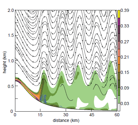
Esta reflexión permite que el perfil ondulatorio se extienda en la horizontal mucho más allá de la montaña, que será más extenso si se producen repetidas reflexiones. Estas ondas se llaman ondas a sotavento atrapadas. En las zonas oscuras de la figura se pueden formar nubes.

En las zonas oscuras de la imagen anterior se forman frecuentemente nubes lenticulares (que tienen forma de OVNI). Varias capas pueden formar estructuras repetidas, duplicatus. En este artículo de @lariojaMeteo tenéis más info sobre ellas, con ejemplos de sistemas montañosos.


Muchas veces habréis observado que si un río pasa a través de una pequeña piedra, se pueden formar remolinos detrás de ellas. Pues este tipo de remolinos turbulentos se pueden formar debajo de la ondulación debido a la fricción de la superficie, que genera vorticidad (giro)

Estos remolinos se forman cerca de la superficie y forman un tipo de nubes llamada rotor. Un ejemplo muy frecuente se da cerca del Peñón de Gibraltar. También se pueden formar encima de las montañas nubes capuchón, pero no son rotoras


Hasta ahora todas las soluciones de ecuaciones de ondas era para casos lineales, pero hay efectos no lineales, es decir que la respuesta se puede ampliar mucho más. Estos efectos no lineales generan intensas aceleraciones en la zona de descenso de la montaña (sotavento)
Esto se puede entender fácilmente si nos acordamos de lo que es la energía cinética (1/2 m v^2) y potencial (mgz). Si la cinética es mayor que la potencial, una canica puede llegar a la cima de la montaña y descender.
En nuestro caso podemos expresar la energía potencial en función de las fuerzas de empuje a través de la frecuencia de flotabilidad N y la cinética a través de la velocidad del viento U .La razón entre estos parámetros es el numero de Froude Fr=U/hN, h es la altura de la montaña
Por lo que, Fr = número de Froude = energía cinética / energía potencial= velocidad del viento / altura de la montaña x frecuencia flotabilidad =U/hN. Si es mayor que 1, la parcela de aire puede llegar a superar la cima de la montaña y descender.
Hay un problema, y es que cuando Fr>1 la velocidad del viento es mayor que la de onda, que vimos antes que se relaciona con N. En este caso la onda de gravedad no se podría propagar, pero aún así vemos que el flujo es capaz de descender. Esto es debido a efectos no lineales
En la imagen se muestra como se comporta el viento según el número de Froude. Vemos que para Fr>1, caso fluido supercrítico, hay aceleraciones a sotavento (derecha montaña) y para Fr<1 en el otro lado, a barlovento (izquierda), caso fluido subcrítico

Por lo que para tener ambos tipos de aceleraciones el fluido tiene que pasar de subcrítico a supercrítico. (c en ala imagen anterior). Esto pasará si Fr es cercano a uno inicialmente. Entonces al pasar el pico de la montaña el flujo tendrá más velocidad que con la que partió.
Entonces en el descenso a sotavento el viento descenderá rápidamente y cambiara su forma, en lo que se conoce como un salto hidráulico. Es frecuente verlos en caídas de agua en un tanque. Son turbulentos y disipan gran cantidad de energía.
Los efectos no lineales producen que las ondas de montaña cambien su amplitud en la horizontal y que el perfil varía más con la altura. Diversos modelos intentan reproducir todo esto por su importancia de en la aviación, al final del hilo os dejaré algunas simulaciones.

Las ondas de montaña suponen un peligro para los aviones por las turbulencias que producen. Pueden producir fuertes ascensos y descensos en el avión, que se pueda perder el control e incluso daños. Las zonas más peligrosas están cerca de la superficie y la tropopausa.


La tropopausa supone de por sí un peligro en la aviación porque la velocidad cambia mucho con la altura al llegar allí, formando lo que se llama la turbulencia en aire claro si a esto se le sumará las ondas de montaña sería todavía peor. Por eso es muy importante predecirlas.
Por lo que son importantes de predecir tanto las ondas de montaña como las aceleraciones al descender en la montaña por los efectos no lineales. Indicativos pueden ser las nubes que mencionamos antes o estas condiciones que menciona el Marcosky

El viento no tiene por qué subir siempre, se pue quedar estancado si no sube la montaña, como muestra la imagen. En este caso hay una fuerte estabilidad, se suele formar una inversión térmica y el viento tiende a girar a la baja presión por el aumento de las fuerzas báricas.
También hay que considerar los cambios térmicos diarios. Por la mañana el sol calienta el aire y este tiende ascender por la montaña (viento anabático) y por la noche se enfría y desciende. Los ascensos se tienen que compensar con descensos, generando incluso remolinos.

Este tipo de circulaciones se llama brisa de valle y se forman típicamente en la depresión de Guadalquivir en verano. Los ascensos y descensos hacen cambiar la dirección horizontal del viento. Tenéis mucha más info en esta entrada del blog de AEMET


La brisa de valle es más intensa a mediodía y favorece la formación de tormentas. Por la noche forma las condiciones ideales para la formación de niebla porque el viento descendente crea inversiones térmicas en cuya frontera inferior se acumula vapor de agua. Luego se disipan.


Esto serían vientos de ladera, si ampliaramos estos vientos a una estructura tridimensional tendríamos llamados viento arriba y abajo de valle, que pueden generar remolinos, como antes mencionamos. Por otro lado, la humedad y la nieve pueden debilitarlos.

El viento en la montaña además se puede estancar, provocando acumulaciones de aire frío, que luego pueden descender por la montaña y formar incluso un salto hidráulico.
El otro tipo de brisa más común es es el que se da entre la tierra y el mar. Por la mañana, sobre todo en verano, la tierra está más caliente que el mar, lo que genera una zona de baja presión, que atrae el aire fresco del mar, que luego asciende y vuelve al mar.

La divergencia se produce en la capa limite superficial y a la frontera con el flujo de aire en altura se le llama frente de brisa, que puede generar tormentas, como en Baleares. Por la noche, el mar está mas caliente y la circulación se invierte y se le llama terral.

El terral es muy frecuente en Málaga, que se combina con el descenso del aire seco en las béticas por efecto Foehn y genera vientos descendentes muy cálidos. Por otro lado, la convergencia de brisas en Baleares puede generar tormentas

Pasaremos ahora a hablar de fronteras mesoescalares, la separación de aire continental frío y marítimo cálido puede crear frentes costeros. Su interacción lleva a intercambio de calor y se parecen mucho a los frentes estacionarios. Además, suelen formarse en tierra.
Se mueven sobre el aire frío y forman precipitaciones, heladas en el lado frío y lluvia en el cálido. Suelen tener un km de altura y el gradiente de temperatura es inverso al de los frentes de brisa Suelen formarse cerca de corrientes cálidas (como la del Golfo) en invierno.


Otro tipo de frente mesoescalar es la línea seca o frentes secos, que se forma por la interacción entre una masa de aire seco continental y otra húmeda marítima. Son muy típicos en Estados Unidos y también se han visto en España.
Se pueden formar tormentas en la parte este y fuertes vientos y cambia la dirección del viento, como en los frentes sinópticos. Cambian a lo largo del día por la influencia solar en la emisión de vapor de agua y pueden favorecer la ciclogénesis.

Otros tipos de fronteras mesoescalares se pueden formar por la presencia de nubes o porque haya nieve o un tipo de vegetación diferente. Producen diferentes cambios en la humedad y temperatura.
Por ejemplo, se cree que la formación de tolvaneras se ve favorecida por la rugosidad del terreno o porque el aire pase de una zona seca a una con regadío,

Muchos libros también tratan los frentes sinópticos y huracanes como fenómenos mesoescalares. Ya expliqué los frentes en este hilo
Los frentes presentan bandaas mesoescalares de nubes y precipitación que son tratadas como entidades separadas del frente. Las borrascas se relacionan on la llamada inestabilidad baroclínica y estas precipitaciones con un tipo especial llamada inestabilidad simétrica.

Vamos a hablar primero de esas bandas de precipitación. En los frentes fríos se encuentra una banda estrecha de precipitación intensa muy pequeña en la zona donde gira el viento (línea azul) y algunas anchas con precipitación más extensa

La banda de precipitación estrecha es una banda de 1-2 km de extensión. Están controladas por cambios en los gradientes de presión debido a la circulación del frente, a diferencia de las tormentas mesoescalares, que tenían que ver con el CAPE y con entornos inestables.
Estas bandas y sus ascensos asociados forman unos vórtices de escala mesogamma en los que se alternan zonas con lluvias y sin lluvias (zonas núcleo (core) y hueco (gap)), como muestran estas imágenes de radar. Se forman debido a que la lluvia pueden romper los ascensos.

Las bandas anchas de lluvia, en cambio, se mueven de forma independiente al frente. A veces pueden sobrepasar a la banda estrecha, que es única. Su formación está relacionada con la inestabilidad condicional simétrica y la circulación del frente ageostrófica.
El sector cálido del frente frío también puede tener bandas de lluvia, que se pueden relacionar con frentes en alturas y su velocidades ascendentes, pero la explicación es muy compleja.
Los frentes cálidos tienen también una banda de precipitación débil que se desplaza por la pendiente del frente. Se producen por la inestabilidad condicional simétrica, porque el aire alcanza el nivel de condensación al ascender por la pendiente o por ondas de gravedad incluso.

Hablemos ahora de esa inestabilidad simétrica que he mencionado antes. Al principio del hilo hablamos de la inestabilidad de la parcela en la vertical por cambios en la fuerza de empuje, pero también se pueden dar en la horizontal por cambios en la fuerza de Coriolis.
La fuerza de Coriolis desvía la trayectoria conforme la latitud vaya cambiando, por lo que la parcela oscila debido a ellas. Si en la vertical teníamos la frecuencia N, aquí tenemos f=2Ω sen(ϕ) donde omega es la velocidad angular de la Tierra y ϕ la latitud.

Por lo que si una parcela se mueve tanto en la horizontal como en la vertical (en un camino inclinado, por ejemplo) se verá influenciada por las dos inestabilidades. Esto se conoce como inestabilidad simétrica y es una inestabilidad puramente mesoescalar.

Como N se relaciona con la temperatura potencial, que se conserva en ascensos adiabáticos, sin intercambio de calor, se suele representar por líneas de esta magnitud constante (Θ)
Para f se usa el parámetro M que es la diferencia entre f y el momento angular de la parcela por cambiar su dirección, que provoca un cambio en la velocidad zonal al ir de norte a sur por ejemplo.
Normalmente, las superficies de M constante se inclinan más que las de Θ y las parcelas son estables, pero cuando sucede lo contrario serán inestables (izq), esta condición se representa por el producto de f por lo que varía M a lo largo de una superficie de Θ (la derivada).


Esto puede ocurrir cuando hay fuertes gradientes de temperatura y fuerte estabilidad, como ocurre en un frente. Esta condición se puede expresar en función de la vorticidad potencial (el giro por la altura del vórtice (fP<0)
Por lo que esta inestabilidad se puede dar en presencia de cizalladura vertical del viento (que cambie con la altura la velocidad) y se puede ver como una inestabilidad inercial isoentrópica, por lo de ser a lo largo de Θ constante.